


La Mure - Ecurie Bernard - Prunières

maupassant38
User
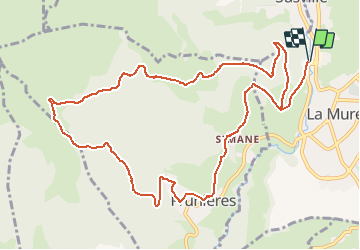

Length
13.1 km

Max alt
1333 m

Uphill gradient
697 m
Km-Effort
22 km

Min alt
857 m

Downhill gradient
698 m
Boucle
Yes
Creation date :
2019-02-22 22:31:07.833
Updated on :
2019-02-22 22:31:07.842
4h39
Difficulty : Medium

FREE GPS app for hiking
 SityTrail
IGN / Geographical institutes
SityTrail Plus
The world is yours!
About
Trail Walking of 13.1 km to be discovered at Auvergne-Rhône-Alpes, Isère, La Mure. This trail is proposed by maupassant38.
Positioning
Country:
France
Region :
Auvergne-Rhône-Alpes
Department/Province :
Isère
Municipality :
La Mure
Location:
Unknown
Start:(Dec)
Start:(UTM)
719673 ; 4976733 (31T) N.
Comments